


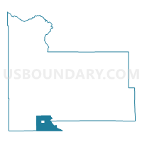
Two Rivers Township Voting District, Morrison County, Minnesota
About
Outline

Summary
| Unique Area Identifier | 603181 |
| Name | Two Rivers Township Voting District |
| County | Morrison County |
| State | Minnesota |
| Area (square miles) | 27.58 |
| Land Area (square miles) | 27.08 |
| Water Area (square miles) | 0.50 |
| % of Land Area | 98.20 |
| % of Water Area | 1.80 |
| Latitude of the Internal Point | 45.81089510 |
| Longtitude of the Internal Point | -94.37966280 |
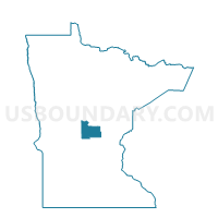
Maps

Graphs
Select a template below for downloading or customizing gragh for Two Rivers Township Voting District, Morrison County, Minnesota


Neighbors
Neighoring Voting District (by Name) Neighboring Voting District on the Map
- Bellevue Township Voting District, Morrison County, MN
- Bowlus Voting District, Morrison County, MN
- Brockway Twp. Voting District, Stearns County, MN
- Elmdale Township Voting District, Morrison County, MN
- Holding Twp. Voting District, Stearns County, MN
- Langola Twp. Voting District, Benton County, MN
- Swan River Township Voting District, Morrison County, MN
Top 10 Neighboring County Subdivision (by Population) Neighboring County Subdivision on the Map
- Brockway township, Stearns County, MN (2,702)
- Holding township, Stearns County, MN (1,139)
- Bellevue township, Morrison County, MN (1,093)
- Elmdale township, Morrison County, MN (1,010)
- Langola township, Benton County, MN (906)
- Swan River township, Morrison County, MN (743)
- Two Rivers township, Morrison County, MN (689)
- Bowlus city, Morrison County, MN (290)
Top 10 Neighboring Place (by Population) Neighboring Place on the Map
Top 10 Neighboring Unified School District (by Population) Neighboring Unified School District on the Map
- Little Falls Public School District, MN (17,471)
- Holdingford Public School District, MN (4,795)
- Royalton Public School District, MN (3,782)
- Upsala Public School District, MN (2,038)
Top 10 Neighboring State Legislative District Lower Chamber (by Population) Neighboring State Legislative District Lower Chamber on the Map
Top 10 Neighboring State Legislative District Upper Chamber (by Population) Neighboring State Legislative District Upper Chamber on the Map
Top 10 Neighboring 111th Congressional District (by Population) Neighboring 111th Congressional District on the Map
Top 10 Neighboring Census Tract (by Population) Neighboring Census Tract on the Map
- Census Tract 7803, Morrison County, MN (6,128)
- Census Tract 102, Stearns County, MN (5,687)
- Census Tract 7808, Morrison County, MN (4,306)
- Census Tract 104.03, Stearns County, MN (3,045)
- Census Tract 202.03, Benton County, MN (2,184)